簡介:一項廣泛用于軍事領(lǐng)域的地形勘查技術(shù),目前將會被應(yīng)用于油田勘察現(xiàn)場。Battelle和美國Oak Ridge國家實(shí)驗室聯(lián)合開發(fā)的 UXO直升機(jī)技術(shù),可以在距地面1米的空中進(jìn)行油田地層目標(biāo)精確探測和繪圖。
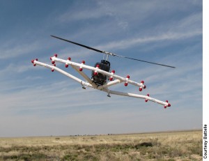
A geophysical survey technology that has thus far been used in military applications is ready for the oil field. The UXO Helicopter technology, which was jointly developed by Battelle and Oak Ridge National Laboratory, promises precise subsurface target detection and mapping for oil fields from just one meter off the ground.
The technology incorporates a geophysical survey technique, which is based on mining and mineral exploration principles, that uses magnetic and electromagnetic sensor systems and global-positioning methods to provide data analysis, digital maps, and target lists. According to William Doll, geophysicist and research leader with Battelle, the major differences between this technology and other types of magnetometer-based and electromagnetic-based surveying systems lie in the detail of data obtained and the time required to capture it.
“Some higher altitude magnetic systems are already used for prospecting in the oil industry, and that is what our technology evolved from,” he said. “The difference is that we fly at low altitudes—on the order of one to two meters above the ground—to generate very detailed subsurface maps.
“We have been mapping a great deal of unexploded ordinances such as bombs and artillery shells for the US military, which was the original application for the technology,” Doll continued. “The technology is mounted via a fixed boom under a helicopter, which then flies at very low altitude over an area to detect subsurface targets including landfills, pipelines, power lines, or unexploded bombs, mortars, and other munitions.”
The magnetometer-based systems will reportedly detect any material that can register a magnetic response in a manner which is faster, more precise, and inherently safer than land-based geophysical detection systems. During a field measurement, an operator in the helicopter monitors the incoming data while the helicopter is moving across the survey area at typical speeds of 30 to 60 miles/hr, depending on vegetative cover and terrain. “The operator is monitoring the data coming in from the magnetometers, and if the values are inappropriate, they can land and make any necessary adjustments or repairs,” Doll said.
An extra level of precision is afforded with the global-positioning satellite (GPS) system that is used to precisely track the survey path during the entire survey. “The ground-based GPS system allows us to correct our data to a precision of approximately 20 cm,” said David Bell, Battelle’s business development manager for the UXO Helicopter technology. “This level of precision is important when you consider that you may be looking for a piece of ordinance that is the size of a soda can. If, for example, the pilot went slightly off course or flew over one mapping line at too high an altitude, the GPS system allows us to repeat measurements on those exact lines quickly, which is a critically important time saver.”
Significant time, cost savings afforded
Bell said that a mapping area of 500 acres or greater is necessary to make the survey economically viable, but that significant cost and time savings are afforded compared to ground-based geophysical surveys. “We can easily survey a 500-acre area in one day, and in fact we have surveyed an 800-acre area in as little as one day. That is with very finely spaced data, lines that would have less than a 2-m separation over the entire area. Most ground-based systems using towed instruments can survey a maximum area of 10 acres per day.
“We’re conservatively saying that there is about a 100-times difference in terms of speed and a 20-times reduction in cost with our system compared to ground-based measurements,” Bell continued.
He pointed to the flexibility of using this airborne system over both land and water as another advantage. “Some of the sites we have surveyed in the past have been combinations of terrestrial and aquatic acreage, and moving from one to the other is a seamless transition for our technology. Other techniques typically require a transition from a land-based system to a different boat-based measurement device, which sets up a disconnect in the measurement and some difficulty in reconciling the data. We are not hampered in this way and can move quickly from measuring over soil to over water without making any changes to our measurement system.”
For applications in which geological, rather than man-made, subsurface structures are being mapped, Battelle incorporates a base station magnetometer which indicates if there are any changes to the earth’s magnetic field—due to phenomena such as sunspot cycle effects—that will require the data to be corrected.
In addition to passive magnetometer systems, the UXO Helicopter system can also be fitted with a time-domain electromagnetic system, which provides for the detailed location of ordnance, even in areas with basalts and lava flows. “Magnetometer systems cannot see anything but the lava flow in these areas,” Doll said. “Electromagnetic systems, on the other hand, are largely insensitive to basaltic geology because they measure the electrical resistivity or conductivity of shallow solids and rock. This is a different geological property that might indicate changes in fluid content at the very near surface, as in the vicinity of a pipeline leak.”
Oilfield applications aplenty
While Battelle has been making unexploded ordnance measurements for military clients since the mid 1990s, they have not conducted any oilfield trials as of yet. However, Doll sees many application areas that could immediately benefit from this technology. “For example, we have generated some interest with an oil company to run unexploded ordnance studies in a sensitive onshore location,” he said. “They want to shoot seismic there, but must ensure that the survey area is free of explosive devices before sending a vibroseis truck and crew into the area.”
The system will also allow operators to evaluate an area for less dangerous subsurface obstacles prior to conducting a seismic survey or drilling a well. “We can pinpoint the location of utilities on site, such as underground cables, and previous wells or pipelines in an area that has not been evaluated for some time,” Doll said. “The UXO helicopter technology could also be used to supplement information from high-altitude magnetic surveys to more accurately identify subsurface magnetic features of geological structures that provide clues on where to drill a well.”
To learn more about the UXO Helicopter technology, visit
www.battelle.org.
楊寶劍 是振威(全球)
石油網(wǎng)的高級技術(shù)編輯,在
石油技術(shù)資訊行業(yè)有八年的學(xué)識和經(jīng)驗。他源源不斷地提供石油行業(yè)全球最新的技術(shù)創(chuàng)新、研發(fā)成果、現(xiàn)場應(yīng)用情況等信息。如果你對該項新技術(shù)有任何的疑問,或者對“新技術(shù)新產(chǎn)品”未來的內(nèi)容有任何問題或建議,請聯(lián)系楊寶劍編輯 +86 10-58236512 Email:allenyo@zhenweiexpo.com 歡迎與行業(yè)互動!
 發(fā)布信息
